
One of the wettest months of March on record has claimed another muddy coup — a 100-foot-wide landslide on a bluff overlooking Admiralty Inlet that wiped out part of a county road.
It was one of several slides county officials have been dealing with in the past few weeks caused by rain-saturated earth that has given way, Bill Oakes, Island County public works director, said Thursday.
“All are related to water in some way,” he said.
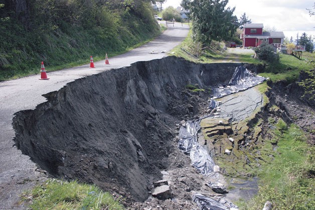
The largest of the recent slides occurred during the week of March 21, when a chunk of earth, trees and other vegetation along Susana Drive on the hill above Bush Point gradually broke free and took part of the roadway with it.
The slide, a short distance west of Smugglers Cove Road, also carried away a portion of a private driveway where it connects to Susana Drive. The area is north of Bush Point and south of South Whidbey State Park.
Roger Leishman, the owner of the house now cut off from the road, said Thursday that the slide area has grown increasingly bigger in the past month, but he wasn’t too concerned that it would endanger his home.
“It’s quite a ways from the ravine to the house. But it’s 25 feet closer than it was,” he said.
He recalled coming home on March 20 from the family’s Seattle apartment. It was dark, and he couldn’t see much, and it only looked like a fence had fallen over.
The next day, there still wasn’t much to see.
“There was a crack in the road and a crack in my driveway,” he said. “It was only a week later that the big crater started to form.”
The pavement then sank a foot as the hillside continued to give way. Neighbors warned Leishman that he’d better get his truck out of his driveway before it was too late.
“Everyone was saying, you’ve got to move your truck, you’ve got to move your truck,” he recalled.
But Leishman didn’t, and then the roadway dropped another 10 feet, leaving much of his driveway — and half of the northern end of Susana Drive — in a crater.
Now his pickup truck is stuck on the other side, but Leishman wasn’t worried, because he said he only uses it for dump runs.
“We’re hoping that spring is here and it stops moving,” he said of the slide.
Oakes said the Susana Drive slide extends about 80 feet down the bluff, and is one of about 30 other slides, most smaller, that have been spotted along that section this past winter and spring. The largest slide was the only one to damage the road, he said.
“That’s a very erosive section of bluff,” Oakes said. He said he visited the slide area this week, and noticed scattered rocks and gravel still breaking loose.
Oakes said a geotechnical consultant has been called in to determine the best way to repair the roadbed, and a report is due in mid-May.
He said Susana Drive will remain closed to vehicles at the area of the slide until the road is repaired.
Meanwhile, no homes in the area appear to be in jeopardy, including Leishman’s, he said.
“We haven’t red-flagged any occupied structures,” Oakes said, although he added that a potting shed on the edge of a residential property at the end of Hidden Lane, which connects to Susana Drive, was carried away by a smaller slide.
Leishman said others in the community told him the last time there was a comparable landslide in the neighborhood was in 1996.
Oakes said the area has experienced other slides before that, notably in the 1980s.
There are several undeveloped lots along the bluff, and they likely will stay that way, he added.
“They would never be approved for modern septic systems,” he said. “There probably won’t be any more development activity.”
Oakes said the Susana Drive slide was the largest and most damaging of five recent slides affecting county roads, four on Whidbey and one on Camano Island.
Two of the Whidbey sites involve roads in and out of the tiny beach community of Glendale south of Clinton, he said.
A portion of Glendale Road about a quarter mile north of the residential area has been restricted to one lane because a slide carried away part of its shoulder. Meanwhile, another restriction has been flagged up the hill out of Glendale on Humphrey Road because of “a slight slump.”
The other slide area on Whidbey involves damage along Driftwood Way in the Ledgewood Beach area north of Greenbank, Oakes said.
Other hillside communities on the South End have also been dealing with reoccurring slides this spring.
In Scatchet Head, homeowners have had to dig out from thick, muddy landslides that have repeatedly spilled across Driftwood Drive.
This past weekend, a major slide buried a section Driftwood Drive and nearly cut off access to the Scatchet Head Community Club and homes on the western end of the privately owned road.
The current slides are only the latest on the South End this year, thanks to near-record rainfall in March.
On March 12 in the Whidbey Shores neighborhood, mud, sand and vegetation, including trees, tumbled from a rain-saturated steep bluff more than
300 feet high, blocking private East Point Drive with a pile of material 100 feet wide and 10 feet tall in places.
On March 15, about 100 cubic yards of mud and debris tumbled into Glendale Creek about 400 feet upstream from the Glendale community, followed by smaller slides in the area in the following days.
Meanwhile, slides and water over roadways were reported during the same period at the Double Bluff Beach area, Columbia Beach and Beverly Beach, along with minor flooding and blocked culverts at Stewart Road, Double Bluff Road, Newman Road, Bounty Loop at Mutiny Bay Road and Goss Lake Road.
“It’s been a very wet spring, contributing to very active landslide conditions,” Oakes said.
He said the geology of Whidbey Island is predominently compacted soil.
“It’s generally stable,” he said. “But when it gets saturated with water, it becomes unstable.”

