
An early idea to bolster pedestrian access along Highway 525 near the Mukilteo Ferry Terminal has government leaders, residents and commuters on both sides of the water calling for a halt.
A representative from the Washington State Department of Transportation presented preliminary plans for pedestrian access projects along the highway at a Mukilteo City Council meeting on Tuesday. A similar presentation about the new ferry terminal’s design and traffic modeling is set for 5:30 p.m. Tuesday, Feb. 23 at Clinton Community Hall on South Whidbey.
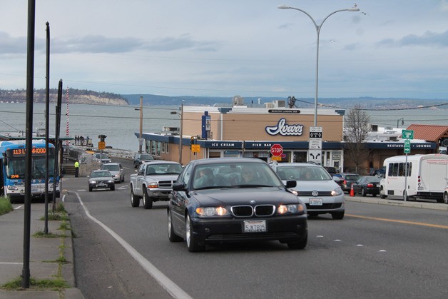
Both access design alternatives focused on ways of getting people on foot and on bicycle from Fifth Street to the waterfront of Front Street, where the ferry terminal currently is. One plan would mean the loss of a southbound lane of vehicle traffic just off the ferry in Mukilteo. Two lanes would merge into one lane, before reaching the intersection with Highway 525. Much of the traffic would then turn left onto the state route, heading up the hill in Mukilteo.
That idea was largely rebuked by Mukilteo residents and city council members as well as Island County Commissioner Helen Price Johnson and others during the council meeting on Tuesday. Concern about traffic jams was a running theme for objections to, and questions about, the state’s idea.
“I think there are some unintended consequences about trying to queue up a long line of buses and logging trucks and cars making one left-hand turn,” Price Johnson said during public comment at the Mukilteo City Council meeting Feb. 16. She cited the current highway with two southbound lanes. One allows for slower vehicles, another for passing traffic.
Traffic queueing at a stoplight could have consequences for the ferry’s ability to offload vehicles, which could in turn cause loading and departure delays.
“I think that could be a problem,” Price Johnson said at the meeting, referring to the preliminary idea of a “road diet” — the term used to describe reducing two lanes of traffic up to Fifth Street into just one.
John Chi, the state transportation department representative, said the traffic and highways division raised those issues with the ferries division and both agencies were working on that modeling to account for freight speed.
“The level of service remains the same, based on the modeling,” Chi said.
Price Johnson was joined by others in Mukilteo and Clinton in their dislike of the idea. Dave Hoogerwerf, the Clinton representative of the Whidbey Island Ferry Advisory Committee and a former longtime ferry commuter, lambasted the design and road diet. A problem statement and solution sheet he emailed to The Record stated that, “It’s going to be difficult enough getting 1.1 million cars per year (the number of cars that transited the Clinton to Mukilteo terminal egress area in fiscal year 2015) around that corner and on to SR 525 with today’s two lanes design, let alone with merged and turning in one lane. In addition, whatever we do in this design, we are locked into it for many years to come. Once that lane is gone, it will never return. Would it be safer and less risky to start with the design as it was presented in the original plan? This plan is not logically sound.”
The road diet design arose after Mukilteo had requested funding for and research about a pedestrian and bicycle bridge adjacent to the highway bridge over the train tracks. Cost estimates ballooned from the originally proposed and budgeted $2.6 million to between $3.5 million and $7 million.
Construction costs increased as basic design elements, largely around the need for ADA compliance, were built into the pedestrian bridge. A low slope meant the bridge had to include a switchback design, said Chi, and would also require the need for an easement on property owned by the Burlington Northern Santa Fe rail company.
Without proper funding in place, the state transportation department looked at other ways of accomplishing the goals without major construction.
With a new bridge too costly, the state looked at an alternative idea. Adding sidewalk width and bike lanes to the existing highway in the Old Town area near the terminal could satisfy those needs. A pair of 5.5-feet sidewalks on each side of the bridge and a pair of 5-feet bike lanes would leave room for three 11-foot car lanes but necessitates the loss of a lane of traffic. The width of the sidewalks was necessary to be compliant with the American Disabilities Act. According to the Federal Highway Administration guidelines, the minimum passage width is 32 inches at a point, 36 inches continuously, and additional width of up to 60 inches is necessary for maneuvering and turning. Even those who supported the pedestrian considerations in the state’s alternative to the separate bridge questioned the effect on traffic flow leaving the terminal.
“I’m pleased to see the bike lanes, I think that’s a nice thing,” Mukilteo Councilman Richard Emery said at the council meeting. “It’s hard to get my mind around how reducing a lane of traffic isn’t going to impact the offloading of the ferries.”

