Forgotten county lots eyed by realtor
Published 1:30 am Tuesday, April 14, 2026
A forthcoming decision by Island County on a zoning issue could determine whether high-density housing can be developed on more than 20 combined acres of land in North Whidbey.
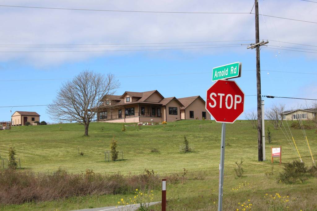
Charlie Moore, a real estate agent in Oak Harbor, applied for a certificate of zoning compliance in December in order to certify the legality of lots on property within a pre-existing subdivision. That land, adjacent to the intersection of Arnold Road and Highway 20, is zoned as rural by Island County and falls within Ebey’s Landing National Historical Reserve.
The certification is a necessary step before housing can be built, but doesn’t necessarily mean high-density development can move forward. County officials would consider issues like whether the property percs, the presence of critical areas and the need for setbacks before issuing permits.
A pre-application summary by the county’s planning department explains that the number of legal lots determines the land’s capacity for housing. The land falls within the Plat of San De Fuca, a subdivision established in the late 1800s which divides it into about 45 lots. Forty-five lots could support 45 dwellings, whereas rural zoning in Island County permits just one dwelling on every five acres, amounting to lower density housing in comparison.
Moore said he would not develop the land himself — rather, he is just preparing it to be developed.
The final say on the land’s zoning rests with county. Jonathan Lange, the county’s planning director, said on April 13 that a decision on the application can be expected “within the next couple of weeks.” A public comment period regarding the application concluded March 31.
Marnie Jackson, executive director of the Whidbey Environmental Action Network — or WEAN — and Alix Roos, executive director of the reserve’s Trust Board, expressed their disagreement with the application in letters to the county dated March 26 and 27, respectively. The letters state that a certification would conflict with zoning codes and design guidelines meant to preserve the land’s rural character.
Jackson explained in her letter that the Washington State Growth Management Act, enacted in the 1990s, “requires that rural lands be protected from urban-level densities and that counties maintain clear distinctions between rural and urban designations.” Roos wrote that the certification “violates” land division and site development chapters of the reserve’s design guidelines.
Those chapters intend to “limit the visibility of new developments,” “preserve distinctive features” of the land and ensure compatibility between new and old buildings. Of note, a historic design review included in the pre-application summary identified several contributing and non-contributing historic structures in the vicinity of the land.
Moore characterized the zoning issue as a “gray area.”
The county asserts that the burden of proving the lots’ legality always lies with the owner, and Moore told the News-Times that chain of title research proved the lots’ legality. He explained that the land should not have to comply with rural zoning limiting lot sizes to five acres because the land was “surveyed and platted prior to that time” and is “grandfathered in.”
The pre-application summary notes that “sometime around 2017, separate parcel numbers were issued by the Island County Assessor’s Office based on the original 1889 Plat of San De Fuca” but clarifies that parcel numbers are not inherently legalizing. Jackson stressed in her letter that parcel numbers are “administrative tracking tools created for tax assessment.”
“These legacy mini-lots were never developed into the urban fabric their promoters envisioned, yet their parcel outlines persist in the Assessor’s records as vestigial artifacts of plans long since abandoned,” she wrote.
Kelly Mauck, the county assessor, explained that around 2018 or 2019, the Assessor’s Office “started to undo lots that were combined for tax purposes only because they were causing issues within our system.” Moore explained that he received a letter from the county detailing its intent to tax the land as about 40 individual lots, a total which Mauck said returns the land to its “original configuration.”
“From our perspective, this is just to properly assess the land,” Mauck added. “We play no role in other parts.”
There are other concerns, too. Roos noted in her letter that “public testimony and submitted comments have raised questions related to historic structures on the property, infrastructure capacity, including water availability, septic systems road safety and cumulative impacts to the surrounding area.”
Jackson noted discrepancies in publicly available information about the certification application as well. A physical notice on the property stated that about 45 lots are up for certification, but the county’s permitting portal seeks certification of 120 total lots. Moore said he has no idea where that number came from.
“These are not minor discrepancies — they speak to whether the public notice requirement was satisfied at all,” Jackson wrote. “The county should require a complete, consistent and accurate application before any further review proceeds.”
Both WEAN and the Trust Board request that the county deny Moore’s certification.
Moore, however, is confident in the work of consultants, engineers and surveyors he hired for the project, and believes a development can be accomplished without sacrificing “our county’s historical flavor.”
“I am very much interested in receiving community comments and suggestions that will be beneficial to our community, to help make it a safe and desirable place to live,” he added.